egm96geoid
R2026bGeoid height from Earth Gravitational Model 1996 (EGM96)
Syntaxes of the egm96geoid function that return referencing vectors
have been removed. Use a syntax that returns a reference object instead. For more information,
see Version History.
Description
returns the height in meters of the geoid at the specified latitude and longitude from the
Earth Gravitational Model of 1996 (EGM96). Specify latitude and
longitude in degrees.N = egm96geoid(lat,lon)
Examples
Find geoid heights from EGM96 by specifying latitude and longitude values in degrees. The result is returned in meters.
lat = 27.988056; lon = 86.925278; N = egm96geoid(lat,lon)
N = -28.7444
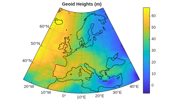
View geoid heights from EGM96 for a region including Europe.
Create a GeographicPostingsReference object that associates each geoid height with a location in geographic coordinates. Specify the latitude and longitude limits of the region in degrees. Specify the raster size as the number of rows and columns to include in the grid of geoid heights. Create the object by using the georefpostings function.
latlim = [30 72]; lonlim = [-25 45]; rasterSize = [100 100]; R = georefpostings(latlim,lonlim,rasterSize);
Create a grid of geoid heights for the region by specifying the reference object as input to the egm96geoid function.
N = egm96geoid(R);
Set up a map using an area of interest (AOI) created from the reference object. Display the geoid heights and global coastlines on the map.
figure aoi = aoiquad(R); newmap(aoi) hold on geopcolor(N,R) load coastlines geoplot(coastlat,coastlon,Color="k",AffectAutoLimits="off")
Add a title and a color bar. Apply a cartographic map layout.
title("Geoid Heights (m)") colorbar mx = gca; mx.MapLayout = "cartographic";
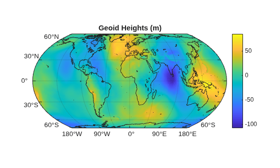
View geoid heights from EGM96 for the entire globe.
Return the geoid heights and a reference object for the globe. The geoid heights are spaced at 15-minute intervals.
[N,R] = egm96geoid;
Display the geoid heights on a world map.
figure
newmap
geopcolor(N,R)
hold onDisplay global land areas on the same map. Add a title and a color bar.
land = readgeotable("landareas.shp"); geoplot(land,FaceColor="none") title("Geoid Heights (m)") colorbar
Input Arguments
Latitude in degrees, specified as a scalar, vector, or matrix. The dimension of
lat depends on the dimension of the geoid heights you want to find.
To find a single geoid height, specify
latandlonas scalars.To find several geoid heights, specify
latandlonas vectors of the same length.To find a p-by-q grid of geoid heights, specify
latandlonas p-by-q matrices.
Data Types: single | double
Longitude in degrees, specified as a scalar, vector, or matrix. The dimension of
lon depends on the dimension of the geoid heights you want to find.
To find a single geoid height, specify
latandlonas scalars.To find several geoid heights, specify
latandlonas vectors of the same length.To find a p-by-q grid of geoid heights, specify
latandlonas p-by-q matrices.
Data Types: single | double
Raster reference for N, specified as a
GeographicPostingsReference object or a
GeographicCellsReference object. The raster reference associates each
element of N with a location in geographic coordinates.
The RasterSize property of the reference object determines the
size of the data grid, size(N).
Output Arguments
Global raster reference, returned as a GeographicPostingsReference
object of size 721-by-1441 with latitude limits [-90 90] and
longitude limits [0 360].
More About
The geoid is an equipotential surface of the
Earth's gravity field that approximates global mean sea level. You can visualize the geoid
as the surface of the ocean without effects such as weather, waves, and land. The Earth
Gravitational Model of 1996 (EGM96) is based on the ellipsoid specified by the World
Geodetic System of 1984 (WGS84), so the egm96geoid function returns
heights above or below the surface of the WGS84 ellipsoid.
Version History
Introduced before R2006aThe egm96geoid function now reports a 3-D geographic CRS when you
return geoid heights for the entire globe. The GeographicCRS property
of the raster reference object globalR contains a
geocrs object with a VerticalCRS property that
stores a vertical CRS.
In previous releases, the geocrs object reported by the function always
contains 2-D CRS information. If your code depends on 2-D CRSs, such as when comparing
horizontal CRSs using the isequal function,
then you can remove the vertical CRS by setting the VerticalCRS
property of the object to [].
Syntaxes of the egm96geoid function that return referencing vectors
have been removed. Use a syntax that returns a geographic raster reference object instead.
Reference objects have several advantages over referencing vectors.
Unlike referencing vectors, reference objects have properties that document the size of the associated raster, its geographic limits, and the direction of its rows and columns. For more information about reference object properties, see the
GeographicCellsReferenceandGeographicPostingsReferenceobjects.You can manipulate the limits of rasters associated with reference objects using the
geocropfunction.You can manipulate the size and resolution of rasters associated with reference objects using the
georesizefunction.Most functions that accept referencing vectors as inputs also accept reference objects.
This table shows the syntaxes of the egm96geoid function that
return referencing vectors and how to update your code to use syntaxes that return reference
objects instead.
| Removed | Recommended |
|---|---|
[N,refvec] = egm96geoid(samplefactor); |
[~,globalR] = egm96geoid; latlim = globalR.LatitudeLimits; lonlim = globalR.LongitudeLimits; globalSize = globalR.RasterSize; rasterSize = 1 + ceil((globalSize-1)/samplefactor); R = georefpostings(latlim,lonlim,rasterSize); N = egm96geoid(R); |
[N,refvec] = egm96geoid(samplefactor,latlim,lonlim); |
[~, globalR] = egm96geoid;
spacing = samplefactor ...
* globalR.SampleSpacingInLatitude;
R = georefpostings(latlim,lonlim,spacing,spacing);
N = egm96geoid(R); |
Syntaxes of the egm96geoid function that return referencing vectors
issue a warning that they will be removed in a future release.
Syntaxes of the egm96geoid function that return referencing vectors
will be removed in a future release.
Return geoid heights from EGM96 that are referenced to a geographic raster reference
object. You can specify GeographicCellsReference or
GeographicPostingsReference objects, or return geoid heights and a
reference object for the entire globe spaced at 15-minute intervals.
Return geoid heights from EGM96 by specifying latitude and longitude in degrees. For example, find the geoid height at a latitude of 42.3601 degrees and a longitude of -71.589 degrees:
N = egm96geoid(42.3601,-71.589);
In previous releases, egm96geoid accessed geoid heights using
WW15MGH.GRD, a file that you downloaded from the Internet. Starting in
R2019b, a grid of geoid heights from EGM96 is included with Mapping Toolbox™, and egm96geoid no longer reads data from
WW15MGH.GRD.
As a result, the egm96geoid function shows improved performance.
For example, this code shows about a 15x speed-up when you return the entire grid of geoid
heights:
function timingTest N = egm96geoid(1); end
The approximate execution times are:
R2019a: 0.1838 s
R2019b: 0.0121 s
This code was timed on a Windows® 10 test system with a 3.6-GHz Intel®
Xeon® W-2133 CPU using the timeit
function:
timeit(@timingTest)
MATLAB Command
You clicked a link that corresponds to this MATLAB command:
Run the command by entering it in the MATLAB Command Window. Web browsers do not support MATLAB commands.
Sélectionner un site web
Choisissez un site web pour accéder au contenu traduit dans votre langue (lorsqu'il est disponible) et voir les événements et les offres locales. D’après votre position, nous vous recommandons de sélectionner la région suivante : .
Vous pouvez également sélectionner un site web dans la liste suivante :
Comment optimiser les performances du site
Pour optimiser les performances du site, sélectionnez la région Chine (en chinois ou en anglais). Les sites de MathWorks pour les autres pays ne sont pas optimisés pour les visites provenant de votre région.
Amériques
- América Latina (Español)
- Canada (English)
- United States (English)
Europe
- Belgium (English)
- Denmark (English)
- Deutschland (Deutsch)
- España (Español)
- Finland (English)
- France (Français)
- Ireland (English)
- Italia (Italiano)
- Luxembourg (English)
- Netherlands (English)
- Norway (English)
- Österreich (Deutsch)
- Portugal (English)
- Sweden (English)
- Switzerland
- United Kingdom (English)