roipoly
Specify polygonal region of interest (ROI)
Syntax
Description
Create Polygon Interactively
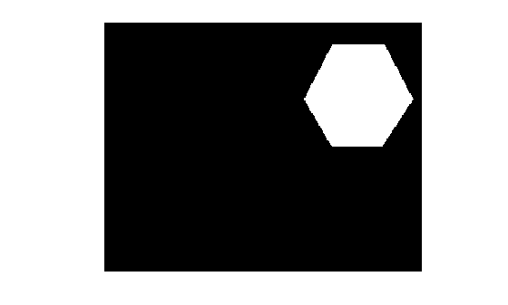
BW = roipolyroipoly returns the mask as a binary image, setting
pixels inside the ROI to 1 and pixels outside the ROI to
0.
With this syntax and the other interactive syntaxes, the polygon selection tool blocks the MATLAB® command line until you complete the operation. For more information about using the polygon selection tool, see Interactive Behavior.
Create Polygon by Specifying Vertices
Specify Additional Output Options
roipoly(___) without output arguments
displays the resulting mask image in a new figure window.
Examples
Read an image into the workspace.
I = imread('eight.tif');Define the vertices of the mask polygon.
c = [222 272 300 270 221 194];
r = [21 21 75 121 121 75];
Create the binary mask image.
BW = roipoly(I,c,r);
Display the original image and the polygonal mask.
imshow(I)
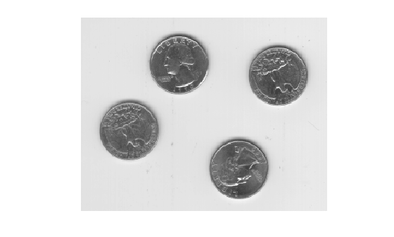
figure
imshow(BW)
Input Arguments
Output Arguments
More About
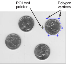
The polygon selection tool enables you to select and adjust polygon vertices interactively using the mouse.
When the polygon tool is active, the pointer changes to cross hairs
![]() when you move the pointer over the image in the
figure. Using the mouse, you specify the region by selecting vertices of the
polygon. You can move or resize the polygon using the mouse. When you are finished
positioning and sizing the polygon, create the mask by double-clicking, or by
right-clicking inside the region and selecting Create
mask from the context menu.
when you move the pointer over the image in the
figure. Using the mouse, you specify the region by selecting vertices of the
polygon. You can move or resize the polygon using the mouse. When you are finished
positioning and sizing the polygon, create the mask by double-clicking, or by
right-clicking inside the region and selecting Create
mask from the context menu.
The figure illustrates a polygon defined by multiple vertices. The following table describes all the interactive behavior of the polygon tool.
| Interactive Behavior | Description |
|---|---|
| Closing the polygon. (Completing the region-of-interest.) | Use any of the following mechanisms:
|
| Moving the entire polygon | Move the pointer inside the region. The pointer changes to a
fleur shape |
| Deleting the polygon | Press Backspace, Escape or Delete, or right-click inside the region and select Cancel from the context menu. Note: If you delete the ROI, the function returns empty values. |
| Moving a vertex. (Reshaping the region-of-interest.) | Move the pointer over a vertex. The pointer changes to a circle
|
| Adding a new vertex. | Move the pointer over an edge of the polygon and press the
A key. The pointer changes shape to
|
| Deleting a vertex. (Reshaping the region-of-interest.) | Move the pointer over the vertex. The pointer changes to a circle
roipoly draws a new straight line between
the two vertices that were neighbors of the deleted vertex. |
| Changing the color of the polygon | Move the pointer anywhere inside the boundary of the region and click the right mouse button. Select Set color from the context menu. |
| Retrieving the coordinates of the vertices | Move the pointer inside the region. Right-click and select Copy position from the context menu to copy the current position to the Clipboard. The position is an n-by-2 array containing the x- and y-coordinates of each vertex, where n is the number of vertices. |
Tips
roipolyalways produces a closed polygon. If you specify input vertex positions of a closed polygon (such that the last pair of coordinates is identical to the first pair), then the length of the output coordinate vectors is equal to the number of points specified. If the points specified do not describe a closed polygon, thenroipolyadds a final point having the same coordinates as the first point. In this case the length of the output coordinate vectors is one greater than the number of points specified.For more information about classifying pixels on the ROI boundary, see Classify Pixels That Are Partially Enclosed by ROI.
For any of the
roipolysyntaxes, you can replace the input imageIwith two arguments,mandn, that specify the row and column dimensions of an arbitrary image. For example, these commands create a 100-by-200 binary mask.c = [112 112 79 79]; r = [37 66 66 37]; BW = roipoly(100,200,c,r);
If you specify
mandnwith an interactive form ofroipoly, anm-by-nblack image is displayed. Use the mouse to specify a polygon within this image.