Choose a 3-D Coordinate System
Coordinate systems represent position on the Earth using coordinates. The toolbox provides functions to transform coordinates between geodetic, east-north-up (ENU), and north-east-down (NED).
Global system like geodetic system describe the position of an object using a triplet of coordinates. Local systems such as ENU and NED systems require two triplets of coordinates: one triplet describes the location of the origin, and the other triplet describes the location of the object with respect to the origin.
When you work with 3-D coordinate systems, you must specify an ellipsoid model that approximates the shape of the Earth. All of the sample coordinates on this page use the World Geodetic System of 1984 (WGS84).
Geodetic Coordinates
A geodetic system uses the coordinates [lat
lon
alt] to represent position relative to a reference
ellipsoid.
lat, the latitude, originates at the equator. More specifically, the latitude of a point is the angle a normal to the ellipsoid at that point makes with the equatorial plane, which contains the center and equator of the ellipsoid. An angle of latitude is within the range
[–90°, 90°]. Positive latitudes correspond to north and negative latitudes correspond to south.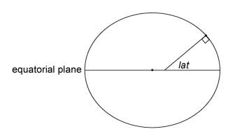
lon, the longitude, originates at the prime meridian. More specifically, the longitude of a point is the angle that a plane containing the ellipsoid center and the meridian containing that point makes with the plane containing the ellipsoid center and prime meridian. Positive longitudes are measured in a counterclockwise direction from a vantage point above the North Pole. Typically, longitude is within the range
[–180°, 180°]or[0°, 360°].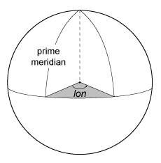
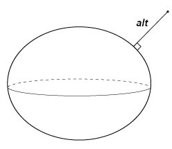
alt, the ellipsoidal height, is measured along a normal of the reference spheroid.
East-North-Up Coordinates
An east-north-up (ENU) system uses the Cartesian coordinates
[xEast
                yNorth
                zUp]
to represent position relative to a local origin.
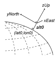
The local origin is described by the geodetic coordinates
[lat0
                lon0
                alt0]
. Note that the origin does not necessarily lie on
the surface of the ellipsoid.
The positive xEast-axis points east along the parallel of latitude containing lat0.
The positive yNorth-axis points north along the meridian of longitude containing lon0.
The positive zUp-axis points upward along the ellipsoid normal.
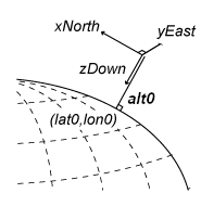
North-East-Down Coordinates
A north-east-down (NED) system uses the Cartesian coordinates
[xNorth
                yEast
                zDown]
to represent position relative to a local
origin. The local origin is described by the geodetic coordinates
[lat0
                lon0
                alt0]
. Typically, the local origin of an NED system is
above the surface of the Earth.
The positive xNorth-axis points north along the meridian of longitude containing lon0.
The positive yEast-axis points east along the parallel of latitude containing lat0.
The positive zDown-axis points downward along the ellipsoid normal.
An NED coordinate system is commonly used to specify location relative to a moving aircraft. In this application, the origin and axes of an NED system change continuously. Note that the coordinates are not fixed to the frame of the aircraft.
Tips
If you are transforming coordinates between ENU and NED systems with the same origin, then you do not need to specify a reference ellipsoid or the coordinates of the origin.
See Also
enu2lla | lla2enu | lla2ned | ned2lla
References
[1] Guowei, C., B.M. Cheh, and T. H. Lee. Unmanned Rotorcraft Systems. London: Springer-Verlag London Limited: 2011.
[2] Van Sickle, J. Basic GIS Coordinates. Boca Raton, FL: CRC Press LLC, 2004.
Select a Web Site
Choose a web site to get translated content where available and see local events and offers. Based on your location, we recommend that you select: United States.
You can also select a web site from the following list
Americas
- América Latina (Español)
- Canada (English)
- United States (English)
Europe
- Belgium (English)
- Denmark (English)
- Deutschland (Deutsch)
- España (Español)
- Finland (English)
- France (Français)
- Ireland (English)
- Italia (Italiano)
- Luxembourg (English)
- Netherlands (English)
- Norway (English)
- Österreich (Deutsch)
- Portugal (English)
- Sweden (English)
- Switzerland
- United Kingdom (English)
Asia Pacific
- Australia (English)
- India (English)
- New Zealand (English)
- 中国
- 日本Japanese (日本語)
- 한국Korean (한국어)