Main Content

pc2scan

Convert 3-D point cloud into 2-D lidar scan

Since R2022a

    Description

    example

    scan = pc2scan(ptCloudIn) converts an input point cloud into a 2-D lidar scan and returns it as a lidarScan object.

    scan = pc2scan(ptCloudIn,tform) specifies the transformation tform of the input point cloud into the 2-D lidar sensor coordinate system, and then converts it into a 2-D lidar scan. tform represents the pose of the 2-D lidar sensor with respect to the point cloud origin.

    scan = pc2scan(ptCloudIn,Name=Value) specifies options using one or more name-value arguments. For example, pc2scan(ptCloudIn,ElevationAngleTolerance=5) selects points with elevation angles in the range [-5, 5] degrees to generate the scan.

    Examples

    collapse all

    Create a velodyne PCAP file reader object.

    veloReader = velodyneFileReader("lidarData_ConstructionRoad.pcap","HDL32E");

    Read point cloud data from 0.3 seconds after the start time of the file by using the readFrame method. Display the point cloud.

    veloReader.CurrentTime = veloReader.StartTime + seconds(0.3);
    ptCloud = readFrame(veloReader);
    pcshow(ptCloud)

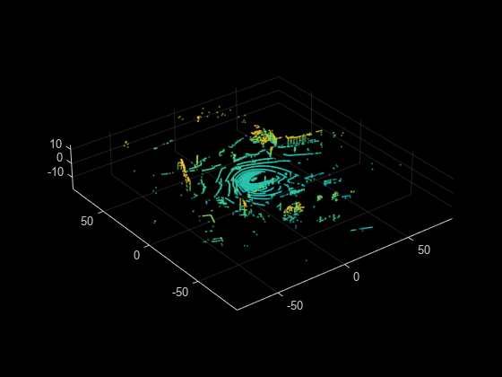
    Segment the point cloud and remove ground points.

    groundPtsIdx = segmentGroundFromLidarData(ptCloud);
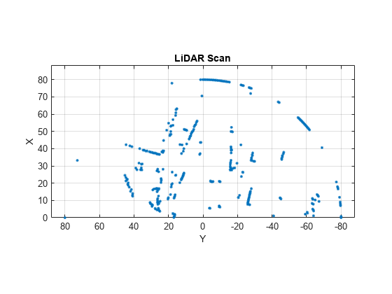
    nonGroundPtCloud= select(ptCloud,~groundPtsIdx,OutputSize="full");

    Convert the point cloud into 2-D lidar scan and display the output.

    scan = pc2scan(nonGroundPtCloud,ElevationAngleTolerance=[-5 2]);
    figure
    plot(scan)

    Input Arguments

    collapse all

    Input point cloud, specified as a pointCloud object.

    By default, the function assumes the input point cloud is in the sensor coordinate system with the point cloud origin at the sensor center, and the sensor capturing the point cloud has no rotations about the coordinate axes.

    You must specify the Location property of the pointCloud object in meters.

    Rigid transformation between the 2-D lidar sensor and the point cloud origin, specified as a rigidtform3d object. The function uses tform to convert the input point cloud into the 2-D lidar sensor coordinate system.

    Note

    By default, the function assumes the input point cloud is in the sensor coordinate system, and the sensor capturing the point cloud has no rotations about the coordinate axes if you do not specify tform.

    Name-Value Arguments

    Specify optional pairs of arguments as Name1=Value1,...,NameN=ValueN, where Name is the argument name and Value is the corresponding value. Name-value arguments must appear after other arguments, but the order of the pairs does not matter.

    Example: pc2scan(ptCloudIn,ElevationAngleTolerance=5) selects points with elevation angles in the range [-5, 5] degrees to generate the scan.

    Elevation angle tolerance, specified as a positive scalar or two-element vector.

    When generating the 2-D lidar scan:

    • When you specify a positive scalar, the function selects only the points of the input point cloud with elevation angles in the range [-ElevationAngleTolerance, ElevationAngleTolerance].

    • When you specify a two-element vector, , the lower value represents the minimum elevation angle, MinElevationAngleTolerance, and the higher value represents the maximum elevation angle, MaxElevationAngleTolerance. The function selects only the points of the input point cloud with elevation angles in the range [MinElevationAngleTolerance, MaxElevationAngleTolerance].

    Lower values of ElevationAngleTolerance can result in a more accurate output scan. The values must be in the range [ –90, 90]. Units are in degrees.

    Data Types: single | double | int8 | int16 | int32 | int64 | uint8 | uint16 | uint32 | uint64

    Angle between the consecutive scan lines of the 2-D lidar sensor, specified as a positive scalar. Lower values can result in a finer scan output. Units are in degrees.

    Data Types: single | double | int8 | int16 | int32 | int64 | uint8 | uint16 | uint32 | uint64

    Scanning range of the 2-D lidar sensor, specified as a two-element vector of the form [min max]. Units are in meters.

    Note

    If the function is unable to find points within the maximum scan range limit, then the function returns the points at the maximum range value. This results in a ring-like structure in the output scan. To avoid this, specify the maximum scan range value as inf.

    Data Types: single | double | int8 | int16 | int32 | int64 | uint8 | uint16 | uint32 | uint64

    Scanning angle limits of the 2-D lidar sensor, specified as a two-element vector of the form [min max]. This vector defines the horizontal field of view of the sensor. Units are in degrees.

    Data Types: single | double | int8 | int16 | int32 | int64 | uint8 | uint16 | uint32 | uint64

    Output Arguments

    collapse all

    Output 2-D lidar scan, returned as a lidarScan object.

    Algorithms

    The function follows these steps to convert a point cloud into a 2-D lidar scan.

    • Converts the input point cloud to the 2-D lidar sensor coordinate system using the specified transformation tform. If you do not specify tform, the function assumes the data is in the sensor coordinate system.

    • Projects the points on the xy-plane. For each projected point, the function computes the angle and range. The angle is counter-clockwise positive along the x-axis, and the range is the distance from the origin.

    • Selects the points whose angle and range are within the specified ScanAngleLimits and ScanRangeLimits, respectively.

    • Selects the points whose elevation angle is within the specified ElevationAngleTolerance.

    • Computes the scan line index for each point from the measured angle. The function assigns a scan angle to each scan line, starting from the first scan line and assigning it the value of the first element of ScanAngleLimits. The function then increments the angle in steps of the specified ScanAngleResolution to the remaining scan lines.

    • By default, each scan line index has the maximum range. For multiple scan lines with same index, the function assigns the range value of the point closest to the origin.

    • Generates the 2-D lidar scan using the scan angles and the range values.

    Extended Capabilities

    C/C++ Code Generation
    Generate C and C++ code using MATLAB® Coder™.

    GPU Code Generation
    Generate CUDA® code for NVIDIA® GPUs using GPU Coder™.

    Version History

    Introduced in R2022a

    expand all